Category: Sightseeing

  • Arizona and Utah Roadtrip

    Arizona and Utah Roadtrip

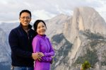
    This trip is about exploring the Colorado Plateau and its many manifestations through Arizona and Utah. Mainly, we’ve planned this trip to marvel at the sandstone formations, layers balanced one on another, shaped by the forces of deposition and erosion. We also find ways to balance time—between baby, play, and work. It’s Daphney’s first long sightseeing road trip, and my laptop is with me so I can remain relatively caught up. Then, there’s the balance between camping and rooming. We had left some of the arrangements to last-minute grabs, and by trip’s end, we will have had four nights in motels and four in tents—the latter being more memorable, of course. And, Daphney will have had reached her tenth night camping in wilderness.

    Zion

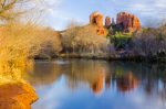
    We arrive in the late afternoon on Thursday and set up at the entrance for picture in front of the sign. The timing is perfect. As we pull away, gusts of wind rip open the sky. The floodgates suddenly burst, drenching everything with torrential rain. The ranger says that this storm is but a sliver on radar, and it should be brief. Once we arrive at the campsite, Yan and I quickly set up when the rain lets up. Then, we head to town to shower and have dinner.

    The next morning, we wake up to clear skies. We drive to town for breakfast. The place lacks changing tables, so Daphney has to balance on a concrete ledge for this diaper change. After this big meal, we pack up and wait in the shuttle bus line to go up canyon. The line reminds me of Disneyland; the crowds are crazy. At the last stop, we hike to the Temple of Sinawava, and it’s here that we decide to take Daphney’s fifth month picture. Every hiker that passes by stops to smile at her. After getting some good shots, we quickly head back and catch a shuttle back to our car.

    Grand Canyon

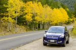
    The road to the Grand Canyon is beautiful, and the section between Jacobs Lake and Demotte is the most beautiful of all, with young stands of aspen aglow, backlit as the sun casts long rays across the hilltop. The road then brings us to the edge of a conifer forest interspersed with golden quaking aspens. After the entrance station, the North Rim Campground comes into view. We quickly set up our tent, as daylight hours are soon ending. The goal is to get to the Grand Canyon Lodge before sunset. From what I’ve read, views from the lodge porch are spectacular.

    Parking and heading into the Grand Canyon Lodge, through the large picture windows, we see the canyon for the first time on this trip. The views had been hidden by forest cover, but now, we stand on the north rim. We easily find seats on the porch and take in the sunset before having dinner in the grand dining room.

    My alarm goes off early Saturday morning. It’s time to head to Point Imperial. We arrive before sunrise and make hot drinks. The car thermometer reads 27 degrees F, and the warm tumblers feel good. The first rays of dawn lights up the pointed peak of Mt. Hayden. Then, the whole canyon turns from magenta to a warm rose-gold. Sunrise happened very quickly, and the sky is now blue as we wander back to our campsite, first stopping to admire roadside fall foliage.
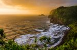
    Vermilion Cliffs

    Packing up from our campsite, we hurry back to Jacobs Lake and turn east. There isn’t much time to stop in at Vermilion Cliffs. Yan pulls out her well-preserved red and black sweater and dresses up Daphney—daughter wearing Mommy’s sweater. We get a quick picture from a roadside turnout.

    Page

    The reservation to tour Upper Antelope Canyon is for 2:00 pm. We arrive early after lunch in town. Because we didn’t book the photographer’s tour, the general tour has a lot of regulations: no tripods, no camera bag, no baby carriers. I’m happy the clerk clarified that a front baby carrier is OK. They tour organizers go through roll call and ask us to get into the van. With crowds of tourists, we are herded into the small canyon entrance. Surprisingly, the tour is pretty well organized, but as advertised, this was not geared for photographers.

    After a short break, we then drive to nearby Horseshoe Bend for sunset. Approaching the edge, I realize that my fear of heights is quite severe—seemingly worse than many people standing on the rim. I crawl and slither until I find a good place to shoot pictures. Yan and Daphney wait safely a few yards behind. The sky is crystal clear, but I’d rather have some cloud cover to add interest and perhaps color.

    There is plenty of time this Sunday morning. We stop by several viewpoints of Lake Powell and enjoy lunch by the marina at Antelope Point.
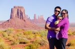
    Monument Valley

    The Navajo Nation is more expansive that we had realized. While on the Antelope Canyon tour, I ask one of the guides how far the Nation extends, and she said: “Starting at that pole and going all the way to New Mexico.”

    Crossing into and out of Utah as we skirt the states’ borders, we pull into the parking lot of The View Hotel. The campground is nearby, and the host asks me to pick our own site. I find one of the best one, sitting along the far ledge overlooking Monument Valley. After setting up, we learn a lot about the Navajo people and nation. Afterwards, we enjoy sunset views from the hotel’s restaurant. Once the stars emerge, the hotel features an outdoor showing of The Searchers—a 1956 John Wayne movie shot in this valley.

    We sleep pretty well except for the rustling of the large tent next door. The Japanese tourists, all four of them dressed in Minions pajamas, had decided to move their tent. Hours earlier, they had arrived after dark, and I think they were setting up their Walmart Ozark Trail tent for the first time. It wasn’t just the crinkling of new tent fabric, but it was also the commotion of the Minions moving their kitchen sink into their eight-person tent.

    I am up before sunrise. The monstrous tent blocks some of our view, so I hike out over to the next ledge to get better pictures. Back at the tent, Daphney awakes. As with most mornings, she is really happy. We have a quick breakfast and take the dirt road into the valley. The drive is beautiful and gives us a different view of the buttes.

    Our next leg takes us into Utah and onto Moab after a quick stop at Goosenecks State Park.

    Arches

    Moab is bustling with activity, and we quickly check in to our room. Arches is just a few miles north, and we join the stream of cars going through the entrance station. We debate about what to do next; the hike to Delicate Arch seems too strenuous based on the description in the park newspaper. We go anyways. The hike is exposed, and I quickly overheat. The warning signs about bringing enough water are correct. At the end, the trail emerges from winding up a rock cliff and spits us out to a spectacular viewpoint. There’s a large crowd. We discover that there is a line for photo ops. I send Yan and Daphney into the line while I set up. Soon, it’s our turn. My remote fails, and I ask a bystander to click the shutter release. As sunset time nears, the crowd self-polices. Delicate Arch is now off limits, and anyone going near it is booed. Everyone awaits that magical moment of last light.

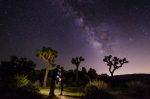
    Staying at Delicate Arch until after astronomical twilight is out of the question, since hiking down in the dark would be very difficult. There were a few serious photographers hiking up to take star pictures though. Instead, we choose to visit the Windows region. At the parking lot, we find more cars than expected, and we notice people light-painting rock faces. I take some shots at Turret Arch. But one of the most spectacular views is a ten-minute hike in—at Double Arch. Peering through both arches, I can see the bright Milky Way stretch across the sky. This view would make one of my favorite photographs from this trip.

    For the second day at Arches, we explore the Devil’s Garden area. We take a morning hike to Landscape Arch. Unfortunately, the trail up to the arch was closed years ago, after a party witnessed a large section crumble to the floor.

    Canyonlands

    From there, we take a short trip to Dead Horse Point and Canyonlands. The views from Dead Horse Point pales in comparison with Horseshoe Bend, but it is still impressive. The visitors’ center gives me good ideas for sunset views, and from the pictures, I decided to get shots from Green River Overlook. First, we explore parts of the Island in the Sky District, including the short hike to Mesa Arch. The view from here at sunset is nothing like those iconic sunrise shots. But from the overlook, as the haze glows orange, an otherworldly mood descends. It is eerily beautiful.

    Capitol Reef

    As we approach the next national park, we are wondering why this place was named as such—why capitol, and why reef. The day before, we had looked at TripAdvisor, and there were many comments about this park being a surprising discovery, a gem of a national park. Many wished they had budgeted more time here.

    Along the road, we pull into Hickman Bridge trailhead, secure the baby carrier, and head off up the trail. We meet only a few other hikers on the trail—much different than at Arches and Zion. We revel in the solitude. The bridge itself is impressive. Digging into my camera bag, I realize that the wide angle lens is back in the car. The best I can do is getting a section of the arch.

    Then, we stop by and see some petroglyph art. These are in the high cliffs above the Fremont River. Further along the river, we stop into the visitors’ center. One of the rangers explains the name: capitol for the dome reminisce of legislature buildings, and reef for the configuration. Capitol Reef would become one of our favorite national parks. The scenic drive brings us to the old Fruita district. We enjoy locally-made old-fashioned ice cream from the Gifford House and pick apples from the historic orchard. Further along the drive, we catch glimpses of the last rays of sun peeking between storm clouds.

    Daphney is especially happy this evening. The baby apple from the Fruita orchard gives her endless joy. She loves her new toy. Because of the excitement, we find it hard to put her to sleep.

    Grand Staircase-Escalante

    Highway 12 is a highlight to drive. It’s mostly overcast with areas of fog, and we skirt in and out of rainstorms. More impressive swaths of turning aspens carpet the hillsides. Although we are in a hurry to get to Bryce Canyon, we take time to take it all in—the cold breeze, misty air, vibrant colors, damp earth, and the smell of a forest after a night of rain. The road through Grand Staircase-Escalante rides a ridgeback with steep drop-offs on both sides.

    Bryce Canyon

    I anxiously pull into Bryce Canyon because we have to find a first-come-first-served campsite. The ranger had said that they fill up every single day. It’s now about 3:00 pm, and surprisingly, there are many spots available. We pitch our tent, and as if on cue, a massive rainstorm hits. The visitors’ center is packed with people trying to get out of the rain. The park video teaches us about the different layers and geography of the Colorado Plateau as well as the balance between buildup and erosion. Bryce is at the top layer.

    After a brief stop in town, we drive all the way to Rainbow Point while visiting various points. Just as we pull out of Bryce Point behind a few lightning strikes, the Park Service closes the road. Natural Bridge is beautiful. As we approach Sunset Point, rain lets up and allows us to do our planned hike along the Navajo Loop Trail. The first few steps in the clockwise direction bring us down into a cartoonish landscape, where people are miniaturized amidst hoodoos. The trail is less muddy than we expected. We round the bottom of the loop and climb back up along a section known as Wall Street, making it back in time for sunset. A beautiful rainbow greets us the moment we crest the rim, bringing smiles to both Yan and Daphney.

    Tonight, Daphney enjoys her first campfire. Even though it’s cold and wet out, she marvels at the flickering flames. This night, however, does not go well. It’s around 2:30 am. She’s hungry and had tried to wake us up. Now, she’s frustrated and can’t be calmed. Yan and I are sure that the entire campground is awake, listening to a screaming baby. We take her to the car, close the doors, calm her down, and finally get her to feed. Then, all is well. We head back to the tent. The stars are out. Everything is still.

    This morning marks Daphney’s completion of ten camping nights. We feel so blessed that she is generally cooperative. We hope she learns to love the outdoors. From here, we pack up and head home.

    Cedar Breaks

    In Panguitch, I notice a sign—Highway 15 to the right, Cedar Breaks to the left. Having planned to speed home, I turn to Yan and discuss taking a scenic detour. We’re just about there, so why not? We wind through forest and come up to a viewpoint. The amphitheater from Chessman Ridge Overlook is impressive, smaller than Bryce Canyon though much steeper. Our favorite place turns out to be the lovely visitors’ center with its cozy fireplace. The large picture window opens to views of cliffs and hoodoos. Why cedar, and why breaks? The ranger explains that cedar is a misnomer, as the early settlers mistook the juniper trees as cedars. To me, they look like cedar trees as well. Breaks apparently refers to the edge of usable land.

    Descending from this national monument, we find ourselves in Cedar City. After lunch, we jump onto the highway. Yan takes over for part of the drive.

    Soon, we find ourselves back home. It was an amazing nine days and eight nights—four in tents and four in hotels. Balancing work and family time is challenging, but we learned a lot about, not only about how the whole Colorado Plateau was formed and eroded, but more importantly, about how to juggle the demands of work and life. These skills should be come handy in the days and years to come.

  • Seattle, Mt. Rainier, and the Olympic Mountains

    Seattle, Mt. Rainier, and the Olympic Mountains

    We’re heading to Seattle for me meeting at the American Orthopaedic Association. This first flight for Daphney goes well, and she isn’t the least bit bothered by the cabin pressure changes.

    Aside from the meetings, Seattle brings us great opportunities for sightseeing. Daphney gets her first rental car ride. She visits the original Starbucks. We have breakfast at Lowell’s and do more touristy things. We bring her to the Space Needle and nearby Chihuly Garden and Glass. The after dinner hike up to Kerry Park gives us that expansive view of Seattle’s skyline.

    Then, we visit nearby national parks: Mt. Rainier and the Olympic Mountains. Our trip to Mt. Rainier National Park marks Daphney’s second month. Then, taking the ferry to Bainbridge Island, we tour the northern part of the Olympic Peninsula. We enjoy lunch at the Oak Table Café in Sequim, catch up with friends, and tour lavender fields. Then, we journey to Hurricane Ridge, where I run into a former resident, Chad Harbour, and his family. Lake Crescent Lodge has the most beautiful dining views. At the end of the day, we take the short hike to Sol Duc Falls, where triple waterfalls cascade over rock outcroppings.

    We wake up on our last morning to the view of a lovely sunrise over a calm sound, silhouetted by Mt. Baker in the far distance.

  • San Diego Trip

    San Diego Trip

    Going to San Diego for Bill and Kathleen’s wedding gave us a chance to do some side excursions. I introduced Yan to the bamboo collection at Quail Botanical Gardens, now known as the San Diego Botanic Garden. The visit also took us to San Diego Zoo Safari Park. One of the highlights was the tram ride, where the conductor showed us one of the last remaining northern white rhinoceros.

  • Beach Outing

    Beach Outing

    We had gone to Newport Beach earlier in the afternoon, where CLC Boats was having a wooden boat show in the back bay. Yan and I got to try out some handmade kayaks and rowboats. We brought a nice cold lunch as well: chilled soba with dipping sauce. The boats provided inspiration for a future project, since my previous kayak burned down.

    After being in the sun for half the afternoon, it’s time to find shade. We drove south on the Pacific Coast Highway and end up at Dana Point’s Salt Creek Beach, which is one of my favorite beaches. I brought our unique kite. It doesn’t look like it should fly, but apparently, by virtue of the Magnus Effect, there is enough lift to make it airborne. There wasn’t much of a breeze, but we managed to keep the kite up there for part of the time.

  • Picnic at the Huntington

    Picnic at the Huntington

    The Huntington Library is holding its last summer evening concert event on the lawn. There are only a few times when the gardens are open beyond 4:30 pm, and this is the perfect opportunity to enjoy the grounds around sunset.

    For lunch, we grilled some vegetables and made focaccia sandwiches from scratch. The chamber orchestra played classical and contemporary hits while everyone enjoyed dinner on the lawn.

    Afterwards, there was time to roam the gardens and experience that golden hour of magical moments when the sky transitions from blazing bright to the warm glow of sunset.

  • Joshua Tree Picnic

    Joshua Tree Picnic

    The main purpose of this trip was to check out the summer Milky Way. I had gotten a wide angle lens, and this is the perfect opportunity to try it out.

    After having tea with friends this afternoon, we timed our arrival to Joshua Tree right at sunset. Surprisingly, even though it was late, the entrance station was still opened, and we opted to get the annual pass.

    The picnic dinner turned out perfectly. As we watched the sky turn purple and then dark, we had a kale salad followed by a Thai pasta salad, together with black plum juice. We used our picnic basket for the first time here.

    Then, the stars emerged. We made our way to Hidden Valley, where we talked along some of the trails at night, watching the Milky Way emerge.

  • Exploring Kauai

    Exploring Kauai

    Today will be an exploration of the southern part of the island. After a lazy breakfast, we find a seal on the beach. A sign describes this tagged individual that looks withered. She had just given birth and is here to rest. Then, we drive down to Po‘ipu. Snorkeling is pretty good. The clarity is reasonable, although not as nice as the pristine waters around Thailand’s Ko Phi Phi. From the beach picnic area, we find ourselves marveling at how blue the water looks, where the beautiful green lawn juxtaposes with the cobalt sea and clear sky. We find more ocean views as we enjoy virgin drinks and fish tacos and tofu wraps for lunch at the Beach House.

    Further down the road, Allerton Gardens is a delight. Our tour guide, Kevin, who has degrees in botany and Polynesian culture goes over this place’s history, identifies plants that Queen Emma planted herself, and points out movie spots. Jurassic Park’s dinosaur eggs were nestled among the garden’s banyan tree roots. We take a picture near the spot. Across the street is the Spouting Horn, where a lava tube connects the rocky crag with the sea. This is Kauai’s version of Old Faithful, Kevin had told us. We see the similarities, although the interval is more on the order of seconds, rather than ninety minutes.

    Koloa’s old town is small but charming. After that, we find ourselves strolling along Hanapepe’s Art Walk, which happens every Friday night. From the crowded main street, we imagine the sunset as the Sabbath begins. We make our way back to the eastern shore, and along the way, we stop into Masa’s Sushi for dinner. We decide to try raw fish: tuna rolls and ahi sushi. Raw fish turns out to be tolerable and actually pretty good.

    Day 20 starts out with another lazy breakfast: spinach mushroom omelets with multigrain toast, Greek yogurt, fresh cherries, and apples. Today will be an exploration to the north. Our first stop is Hanalei Bay. We find beachfront parking and walk out to the end of the pier to snap some pictures. Then, the plan is to hike part of the Na Pali coast. On the drive there, we find some beautiful spots along the coast and stop for pictures at Lumaha‘i Beach. By this time, deciding on the timing is difficult, as a hike will cause us to skip lunchtime; it’s too early to eat now though. We figure we could visit another location before lunch, and the Kilauea Point National Wildlife Refuge and Lighthouse seems like a good idea. Soon, we’re marveling at the acrobatic flight of seabirds out on this craggy point. We have lunch at the Kilauea Fish Market nearby, where we sample raw ahi marinated with sesame and green onions and have the traditional plate lunch: two scoops of brown rice, a side of salad, and some protein. In this case, it’s seared ahi and mahi mahi.

    We make our way back along the same highway to the Kalalau trailhead and while passing through town, we find a cute church. The Wai‘oli Hui‘ia Church, originally founded in 1834, was built in 1912 and has beautiful stained glass windows. We find hymnals and programs printed in Hawaiian. Leaving the church, we cross into Ha‘ena State Park, where a picturesque stream is dotted with mini waterfalls. Just as we park, we are slammed with a huge rainstorm. We figure it would be a nice time to take a nap. After the showers let up a little, we venture out to Ke‘e and the Kalalau trailhead. Many hikers heading out are drenched. We hike the first hundred yards and agree that it is better to turn back. Instead, we find some beautiful cover among the ironwood trees at road’s end.

    On the way back, we visit Kilauea’s Art Walk. Despite the intermittent showers, people seem oblivious to the rain. Here, we see Scuba Tom’s display again, showing the same amazing photographs of turtles and other sea creatures as displayed at Hanapepe’s event last night. From here, we go chasing the sunset. Earlier, we had scouted a spot near Anini Beach, and we pull up about fifteen minutes early. We see a taxi pull up, bringing a well-dressed couple. Then, a woman pulls up in a truck. We step out and walk out onto the rocky shore, and to our surprise, we find an oceanfront wedding taking place. This special Sabbath day ends with this beautiful wedding, where the sun paints a ring of fire among the clouds.

    We find a late dinner at The Bistro in Kilauea, where we sample fries made from purple sweet potatoes grown on the Big Island. Then, there is more ahi.

    Sunday begins with another lazy breakfast on our lanai. This time, though, it’s a bit more rushed, since we are planning to hike the 11-mile loop starting with the Awa‘awaphui Trail.

    We zip off and circle around the southern shore, reaching Waimea and turning northward to wind up the ridgeline. Along the way, we stop and take in the views from the Waimea Canyon Lookout. There are helicopters zipping through the canyons as well, sightseeing the same way we did three days ago. Then, there are more great views across from the Pu‘u Ka Pele picnic area. Before long, we reach the Koke‘e Museum, where we ask for trail suggestions. The ranger tells us that the loop trail connector is closed off and suggests the Pihea Trail instead, so we head up to the Kalalau Lookout. The sky and water are a deep blue, and only a few clouds paint the mountaintops. Below is the verdant Na Pali – Kona Forest Reserve.

    Just further down the road, at the Pu‘u o Kila Lookout, the Pihea Trail takes off. We figure that if we spend a half hour hiking in, we could return in time for a picnic lunch. At first, it is a fairly easy scramble down a wide dirt trail, but this route becomes very muddy and slippery in places. We find ourselves following the ridgeline as the trail heads east from the parking lot, and each time the trees part and we glimpse the valley, the view is as spectacular as the one before. At about a mile, we watch the clouds roll up and abut the ridge, never quite gaining enough energy to cross over to the leeward side. Yesterday, when we reached Ke‘e Beach, we arrived at road’s end. And now, we’ve circled to the other side of the island and got to the other end. Having explored both termini, it’s time to head back.

    Back at the Koke‘e Museum, there is an old picnic table in the middle of a natural lawn. The surrounding trees make this place look like something one might find in Yosemite, except that the field is overrun with wild chickens. We picnic here: trail mix, lettuce wraps, coconut squares, English muffins, vegetarian sausage.

    Despite trail closures that complete the loop, we decide to hike down the Awa‘awapuhi Trail anyways. The trail descends steeply through thick forest. Many of the trees are labeled with their Hawaiian names. We had heard that the best views are at the third mile marker, but we’re doubtful that we will make it that far. About a half hour in, the clouds rolled over into the valley and give a light sprinkle, and at this point, we are in a beautiful valley blanketed in fern fronds and fiddleheads. After taking pictures here, we head back. We pass by the museum again where we wash up in the outdoor restroom and snack on apples.

    We figure it’s best to head down now, taking our time to enjoy some of the sights we passed earlier. At the Pu‘u Hinahina Lookout, we stare into the Waimea Canyon again, but this time, we notice people along a ridge to the left, standing on ledges that are thousands of feet above the valley floor. Thinking that this is probably the last section of some treacherous trail, we look at each other and are happy that we didn’t get to this point on the Awa‘awapuhi, as the vertiginous cliffs and slippery trails do not make a good combination. Beyond the Pu‘u Ka Pele picnic spot, between the mountain ridges just off to the left, there are great views of Waipo‘o Falls.

    Approaching Kekaha, we figure it would be nice to chase the sunset again. The Lonely Planet mentions that Kehaha Beach Park is a nice place to do just that, so we drive around to find it. After picking the spot, we drop into Kalapaki Joe’s in Waimea for dinner—more ahi. Here, we look up the position of the sun and find out that it will be setting 294 degrees east of north. Judging from the map, going to Kekaha puts the sun far to the right of the shoreline. We agree to look for a better place. On Google’s map, it looks like there is a phalanx that juts out just south of Pakalas. Heading there, we pass by the Russian Fort Elizabeth, settled two centuries ago this year when they left their Alaskan base and tried to gain dominance in the Pacific. We take some pictures of the golden sky. Having only fifteen minutes to go, we rush back along the highway to a turnoff one or two streets beyond the post office. Instead, we find that all the roads heading to shore are marked as private property. Having no choice, now with the sun low in the sky and piercing our eyes, we speed back to the Russian Fort.

    It is here that we have one of the most spectacular sunsets during our time in Kauai—the silhouetted trees, the rocky beach, the river flowing into the sea, and the bright amber disk dipping behind a faraway knoll. We take in every moment as the evening begins and linger for another half hour while the first stars emerge. The nearly full moon, suspended in silver mist, sneaks a peak through the branches.

  • First Days in Kauai

    First Days in Kauai

    Through all the busy-ness of wedding planning and hecticness of travel, we had not had a chance to plan the activities on Kauai. This is the first order of business in Honolulu. We make several phone calls and book the next day’s activities during the transit. The hop to Lihu‘e is easy. Our luggage comes out very quickly, getting the rental car through Budget’s Fastbreak is easy, and soon, we’re heading out for lunch. We crave Thai food and find a place near the airport called Gingbua, or Lotus Stem. The food evokes memories from the previous week.

    Waipouli Resort and Spa is a wonderful surprise. Centrally located for island travels and situated right on the beach, we open the doors to modern oceanfront living. We decide we would make breakfast together every morning and enjoy each day’s first meal and sunrise on our balcony overlooking Kauai’s eastern shores. First, though, there hula shows at the Coconut Marketplace and the Marriott Courtyard that we catch. Back at our resort, we have our first dinner at the Oasis on the Beach. The seared ahi will be the first of many more meals of ahi to come—grilled, raw, marinated.

    Day 18 starts off bright and early heading out of Lihu‘e. We check in at Island Helicopters for a flight tour. Before long, we take off and circle the island, first up and over the southeastern ridge, then along Po‘ipu and the sunny southern coast before swinging over to what is known as Jurassic Park Falls. From there, we ascend over several more ridges and end up in the Waimea Canyon for spectacular views. Heading up to the northwest corner, we dive in and out of slots along the Na Pali Coast. The pilot swings around this spectacular coast another time, flies over Hanalei Bay and taro fields in the valley, introduces us to Princeville, and then heads back to the interior mountains for the last time. Then, we cross a ridge and end up in the Wailua drainage canyons and follow river back to the heliport. What a phenomenal introductory overview of the island.

    The afternoon is spent kayaking the Wailua River upstream to its north fork. Moored in this fork, we stop for lunch: multigrain toast sandwich stuffed with tempeh and Maui onion potato chips. Then, we beach our boat and take a muddy trek up to Uluwehi Falls, otherwise known as Secret Falls in the marketing department. The trail is a slippery muddy mess, with each divot filled with rainwater. We meet crowds on this trail to a waterfall that is anything but secret. The falls itself is beautiful, but the feral chickens are too friendly. We had been warned to not feed them, as it will be hard to peel away once they find an easy handout. At the base of the falls, we snack on baby bell peppers and hummus dip while keeping the chickens away.

    There is time left by the time we get back and clean up. We decide that chasing sunsets will be fun excursions when possible, so we strike out to the Kilauea Lighthouse to find that it had closed at 4:00 pm. Backtracking, we find a knoll from where we can see the faraway coastline with the Na Pali range rising out of the ocean. Soon, the last sliver of sun sneaks beneath the clouds and dips below the horizon.

    Then, we enjoy a very nice dinner at Hukilau Lanai—huki for pulling, named after the pulling of nets to bring in the day’s catch. Here, we try some Hawaiian fish: ono and opah, both seasoned and grilled. The molten chocolate cake comes with whipped cream and ice cream. Now, we are overstuffed.

    Back at the resort, we plan out the next days’ activities.

  • Hong Kong

    Hong Kong

    The time in Hong Kong will be filled with eating and hectic sightseeing. The eating part will be mainly about exploring vegetarian restaurants. Upon landing and then travel by express train into Central, the heart of Hong Kong, we taxi over to Hong Kong Garden, where LockCha Teahouse serves both as a dim sum place and a museum dedicated to tea and teawares. We order all sorts of dim sum—from tofu skin with seaweed to steamed vegetable dumplings. To our surprise, which we later find out about dining in Hong Kong, each person is required to order tea or is otherwise charged anyways. Here, all the tea choices are over US$10 per person. The tea and food arrive, and everything is amazingly good.

    After lunch, we hike to another vegetarian restaurant nearby, called Sum Chai, across from the zoo-arboretum. With the thick Hong Kong humidity, this short walk up to the mid-levels exhausts us, and by the time we reach the restaurant, we’re drenched in sweat. We grab a brochure and leave. Dad suggested another place to eat though. Dinner is equally good at a different restaurant—this time in the Causeway Bay district. Rather than being tofu-based, this restaurant specializes in making realistic reproductions of non-vegetarian things, like Peking duck and sashimi.

    We decide to sleep in and have brunch at Sum Chai. The marinated cold cuts are the best dishes, but we also try the usual dim sum fare of potstickers, shumai, turnip rice squares. After a while, everything seems to be a blur. With an intermission, brunch blends into lunch. The restaurant tells us to leave and come back in the early afternoon, because they are booked solid during the lunch hour.

    From there, we head off to the Star Ferry of Hong Kong harbor. Since days of old, not much has changed—the upper and lower decks, the gangways, the smell of sea water from the harbor, the sound of the drawbridge, the deck hands who coil and throw thick ropes, and the motor rumble as we approach the other side. Only two things seem different: the fare is higher, and the ride feels shorter. On the Kowloon side, we visit Tsim Sha Tsui, the clock tower, and the new giant shopping complex, where there is reprieve from the sweltering humid heat.

    We make it back over to the island side and plan a sunset trip up the tram to The Peak. The line seems short from the outside, but once inside the cramped ticketing area, we will find ourselves stuck in line for an hour before stepping onto the tram. Having nothing to do, we time the intervals: roughly three minutes to load, five minutes between departure and arrival, making an inconsistent eight minutes between launches. We miss the last tram up to catch the sunset and end up first in line for the next batch. The view out the right side is pretty, as the city lights are now glowing and reflecting off the fog. By the time we make it out of the terminal to the outside, clouds circle around the summit. We’re caught in a whiteout. We decide to wait it out and grab dinner first. After dinner, the storm worsens. There isn’t much to see, so we get in the growing line to get off the mountaintop. The sign tells us that the wait is more than a half hour from where we stand. Then, a light rain starts. We find this tolerable, but after about fifteen minutes, the sky opens and pours out a torrential storm. Without an umbrella, among others who came up unprepared, we are now soaked head to toe—camera bag, dress, shirt, jeans—with rainwater mixed with the day’s sweat. Down at the Central terminal, we brave more rain to hail a taxi and make it in the last minute to catch the hotel shuttle. It’s a relief to be back and to clean up.

    Day 16 consists first of errands and then of flights. According to the news, the Hong Kong airport had been shut down for about an hour in the morning, and for an airport already running at capacity with little reserve room, the disruption left delayed flights and stranded passengers. We find ourselves in this mess, and we’re nervous of the domino effect from too much delay in this crucial flight. The leisurely connections will now be very tight connections, and we might not make it to Hawai’i for the last chapter of our honeymoon.

    Boarding finally happens more than an hour later, push-off from the gate is another delay of more than an hour, and we will find ourselves sitting on the tarmac for another hour. The pilot announces that we are fifth in line, behind the backlog of flights. This will take at least another twenty minutes, he says. Thankfully, three hours later, we’re now airborne, and we calculate that we’ll make the connecting flights.

    To help with jetlag, we had consulted with the app that received much media attention last year, called Entrain. According to its recommendations, we are to sleep for much of the flight from Shanghai to Honolulu, but this would not be the case. We are surrounded by first time tourists, a raucous crowd of middle-age and elderly passengers who are simply excited to be in a plane and embarking to an exotic destination. Sleep would be amidst the cacophony. Luckily, the app says it’s more about light and dark exposure, rather than actual sleep. We would later find out that it the recommendations work well. Before long, we’ll be touching down in Honolulu.

  • Bangkok

    Bangkok

    The flight back to Bangkok last night was again without any hiccups. This morning, we decided that we would beat the crowds. Having gotten up early for the buffet breakfast, we make our way to the Grand Palace complex. Already, there are throngs of tourists like ants swarming to get through a keyhole. We take the Thai people entrance and are among the first ones to enter Wat Phra Keaw, the Emerald Buddha Temple, right at opening time. The empty temple looks so different, exuding a calm that will be disrupted moments later from noisy tour groups. We practically have the grounds to ourselves, free to take pictures without fighting with others.

    From there, we slip through into the Grand Palace. The gardeners are finishing their watering for the morning, and the rising sun paints the structures in a serene light. Behind us are the crowds, pouring into the temple. Then, we walk to Wat Po. At this point, we realize that Yan’s bag with passport and phone was left in the temple. We hurry back, check in to lost-and-found, and to our relief, the desk agent identifies us right away. She says the bag had been picked up by a guard and then escorts us through the swelling crowd to the back quarters. Another guard has the passport, looking for a facial match. Thankfully, everything is there.

    The trip to Wat Po is a rush. Again, we’re here before the tourists. The huge reclining Buddha seems to budge against the edge of a too-small temple. With his head propped against one hand, the temple seems barely long enough—not enough for him to completely lie down. His footprints are getting a makeover. Along the exit, the temple resounds with the clink-clink-clink of pilgrims dropping alms into the long row of brass bowls.

    We zip back to the hotel and get ready for lunch. Great vegetarian food is easy to find in Thailand, where many choose to forego meat during religious holidays. May’s Veggie is one such place. We order too many exotic dishes—rich curry, spicy salads bursting with mint and lemongrass, sour green mango garnish over fried tuna flakes.

    In the afternoon, we taxi out of Bangkok down toward the river delta, to a town called Baknam, or Waters’ Mouth. Here, we have a mini reunion at Rossukhon. Dinner’s highlight is mango sticky rice. Apparently, the town is known for their mangos, and my aunt grows the best mangos in town. She had picked them that day and pre-ordered sticky rice flavored with pandan leaves from this restaurant that is known for this dish. Two dishes arrive, heaped full of pale green translucent rice. Two more plates come with sliced ripe mango. We divide up the rice, drizzle on rich coconut cream, and arrange the mango pieces on top. This was one of the best desserts—slightly sweet and fragrant from the pandan, a hint of salt from the coconut drizzle, and flavorful mango, smooth without fibrousness.

    It has been a day of ceaseless eating, as lunch flowed into dinner. We head back to Bangkok early, as tomorrow, there will be an early flight to Hong Kong.

  • Phuket

    Phuket

    Day 7 rolls into Day 8 as we are now stranded at the Kunming airport. The agent at the check-in counter had told us that our flight no longer exists and that we are to check with the international supervisor. Then, we are told that we had been rolled over to the next flight, which will be in the wee hours of the morning. This flight, however, is delayed by about an hour.

    It’s nearly daybreak by the time we reach Bangkok. It turns out that it’s nearly the same time we reached Wenzhou days earlier, which is minus an hour in Bangkok. So, it’s still dark and we get to catch an hour of shuteye. Then, we meet up with family for breakfast.

    After a day of running errands and shopping, we enjoy a gourmet dinner with close friends.

    Given all the flight problems we’ve had, the trip to Phuket on Day 9 is a pleasant surprise: no delays and no gate change. As the southbound flight swerves right and hooks around Ao Phang Nga, little Karst formation mounds appear, first poking above the flat plains, then jutting straight up from the sea. Sunlight reflects off the green waters.

    Phuket is sweltering in a heat wave. The beautifully decorated Sino Hotel, typical of guesthouses, has an open-air lobby and hallways. Luckily, the rooms are air-conditioned. First, we book the next days’ events; then, we get dinner recommendations from hotel staff. Raya turns out to be a disappointment—a tourist trap with mediocre food.

    Our tenth day begins with a nice breakfast spread at the guesthouse. There are hot options, salad, and a lot of Thai desserts. During breakfast, the van driver arrives early. Apparently, he was quoted a time half hour earlier than what we had been told. Anyways, he waits while we finish and gather stuff. We are transported to the marina, where we get on the cruise boat for Ao Phang Nga.

    Torrential rain greets us on the dock and continuous to drench us. The boat hands quickly lower the plastic awnings, but raindrops flying sideways still make it through. But soon, rain gives way to silver clouds and later to blue skies. We visit many islands: Ko Lawa Yai, Ko Phanak, Ko Hong, Ko Tapoo. There isn’t much to do on the first island except for taking pictures among all the tourists and trying to stay away. The highlight is Ko Hong where we kayak through rooms and caves, where forest canopies shade the clear green waters below. Ko Tapoo, also known as James Bond Island, is another tourist trap. There is virtually no standing room at the longtail boat landing dock. From there, we hike over to another side of the island where we find respite along a more secluded beach section. Another highlight is the eagle feeding on the way back. With whistle signals, the eagles descend on the fish pieces that are cast out the stern of our boat.

    Walking along Montri Road, on which our guesthouse is situated, we grab dinner at a local open-air marketplace. The cook-to-order food stalls make pretty good food, and we sample pad thai, pad see-ewe, and fried fish, along with snakefruit and mango smoothies. Everything is surprisingly good.

    After breakfast on Day 11, and this time waiting an hour for a late driver, we arrive at a different marina. Here, we wait again for boat repairs. There will be snorkeling today, and interestingly, masks and snorkels are free with the boat tour, but fins are extra. By speedboat, we arrive in the Ko Phi Phi area, which, like yesterday, is overrun by tourists. The speedboat drivers are amazingly adept at navigating through tight channels and among the traffic jams at all these places. When these speedboats are out of view, traditional wooden longtails complement the picturesque scenes of green hills pushing up from the azure sea. At Monkey Island, we are told that at this particular time, the tide has obliterated the beach. Landing is not possible, but the monkeys are out for handouts. A baby clutches its mother closely as she scrambles along a thin branch to catch some bananas. Then, there is snorkeling, lunch, jet skiing, and more snorkeling. By the end of the trip, we are dripping wet, sticky and salty from the ocean. Showering and changing into fresh clothes bring relief after an activity-filled day.

    Lemongrass Restaurant looks deceptive in that it is empty. We had walked by there the first day on the way to Raya but decide to give it a try anyways, since it is one of the few air-conditioned place in town. The waitresses are delighted that they finally have customers for dinner. We order some classic Thai salads—coconut shoot, papaya, crispy morning glory, wing bean. As it turns out, Lemongrass would become one of our favorite restaurants.

    Day 12 starts out with the usual bountiful breakfast at Sino House. Then, we stroll through charming old town, with all the Sino-Portuguese buildings, some being more dilapidated than others. The Blue Elephant Cooking School is probably the best upkept structure. Cute white bird cages adorn the grounds’ giant banyan tree. For a special treat, we stop by Swensen’s, which happens to be a San Francisco-themed ice cream parlor that is more famous in Thailand than in the States. We exceeded our ice cream quota for the year. For lunch, we go back to Lemongrass to try other dishes, and we agree that this is the best restaurant in Phuket Town.

  • Yosemite and LA

    Yosemite and LA

    This first day of being married begins after catching up on much-needed rest. The wedding ceremony yesterday and the reception last night went exceptionally well, and just about everything went as planned. This morning is beautiful. We stand on the balcony to take in the crisp morning air.

    After a lazy breakfast buffet and getting the rental car, we drive out and join the congested freeway toward LA. Parts of the sections around downtown remain a parking lot for quite some time, and all this reminds us of how nice it is not to have to commute long to work. But before long, we’re out of the gridlock and well along the way to Yosemite.

    Along the 99 to Fresno, we pass along acre after acre of almonds, pistachios, and walnuts interspersed with vineyards. We talk about the California drought and how the almond and alfalfa crops are sucking the state dry, effectively exporting our much needed water to countries like China. After Fresno, the scenery transforms to golden rolling knolls dotted with spreading oak trees.

    Tenaya Lodge is a beautiful resort nestled at the forests’ edge just outside the south entrance to Yosemite. The concierge gives us some things we can do today and tomorrow. The drive to Glacier Point is nice for sunset views, she suggests, and the Mariposa Grove is on the way there. For touring the valley tomorrow, there is the Mist Trail. She tells us to skip Mirror Lake if we are short for time; Mirror Lake should actually be Mirror Meadow to reflect the effects of the statewide drought.

    We decide to take up her suggestion. At Mariposa Grove, we are greeted by two mosquitoes. This isn’t bad, considering that there often is a lot more. It’s probably still early in the season. After taking pictures of some giant sequoias at the entrance to the parking lot, we speed hike to the Bachelor and the Three Graces.

    Glacier Point is cold, windy, and exposed, but the views are stunning. The setting sun doesn’t turn anything red as we had hoped, but it is all so spectacular and breathtaking. We fight the swarms of tourists who vie for photo spots, and after scouting around, we situate ourselves on a giant boulder. The soft light from the cloud-covered sun diffuses the harshness of the landscape. This would make one of our favorite photos from this section of the trip.

    Morning of the second day arrives. We hadn’t noticed that it was already getting late, and by the time we’re ready, it’s time for brunch. The Wawona Hotel makes giant breakfast portions, and we pack our leftover toast for later in the day. From there, we wind our way to Yosemite Valley.

    Although the shuttle system looks confusing on the map, it turns out to be pretty easy to use. We hop on at stop 11 and ride to the trailhead at stop 16. The Mist Trail is crowded. Squirrels along the way are fearless. Rather than beggars, they act like models posing for tourists pictures. Across the main bridge, there is the last water stop. We fill up and find a secluded corner, away from the crowds, where the waterfall and boulders make a nice photo opportunity.

    After a lot of climbing along slippery steps, we finally make it to the top of Vernal Falls. Everyone is wanting a picture at the corner of the railing, just to the side of where the water cascades down the granite lip. We get our one and only chance. All around, there are signs that warn of dangers: falling, drowning. Today, it seems that everyone is heeding those warnings.

    Instead of going back down those slick rock steps, we decide to take the long route around, cutting across to the John Muir Trail and going down along dry swtichbacks to reach that same bridge. Again, we fill with water for the rest of the journey down this trail.

    We get the rest of the afternoon to explore parts of the valley, from the store to the Visitors’ Center and theater. Exiting the park, we do a short hike to Bridalveil Falls. We’re not sure how this waterfall is more bridalveil-like than other ones, but we take a picture to illustrate what we think the name is supposed to refer to.

    Back at the Tenaya Lodge, we order cedar-plank salmon with quinoa from the Sierra Restaurant. Then, a soak in the Ascent Spa closes our quick but beautiful Yosemite experience.

    The third day is filled with driving, first through the same scenery of oak-dotted hills and expanses of crops, then through the traffic gridlock of LA. We make it to Terranea Resort and Spa later than had hoped for, but it is still before sunset.

    The peninsula is a high bluff overlooking the Pacific Ocean. There is a secluded beach just below the swimming pool where our balcony overlooks. From the many crashing waves and tidal ebbs, the boulders are polished smooth like giant smooth lopsided eggs. We then stroll along the trail to the west side, hoping to catch some glimpses of the sunset. The sun, however, is covered by a thick layer of clouds along the horizon. In the distant, there is a picturesque backlit lighthouse.

    Dinner at Mar’sel is fabulous. We enjoy some of the signature dishes there. We both agree that the roasted eggplant and ricotta drizzled with saba is one of their best creations, but the steamed black seabass with melted leeks is phenomenal as well.

    Day four marks our last before leaving the States. The eighteen miles to the airport takes nearly an hour of stop and go traffic along Highway 1. We arrive with plenty of time. This is the first of twenty passes through nine airports. The newly renovated Tom Bradley terminal is buzzing with commercial activity, and this is quite different from the old sterile boarding area of previous years. After having vegetable udon noodles for lunch, we board our flight to Shanghai and close this first chapter of our honeymoon.

  • Sailing to Anacapa

    Sailing to Anacapa

    It’s exactly four weeks until the wedding, and my best man brother Andy put together an amazing guys’ sailing trip.

    Everything had started with a text message from Andy about doing a bachelor party. Coincidentally, on one of my surgery days, the anesthesiologist Brent suggested that we go on a sailing trip. And there it was—the trip plans were hatched. Brent took care of the sailing details, and Andy made sure we would eat well.

    After driving out at daybreak, we all meet up at the Oxnard marina. It’s good to see everyone again. Bill, my med school study partner, had driven up from Dana Point. Brent, Mark, and Daniel work on the catamaran to get it ready. The best man and the rest of the groomsmen—Barth, Jeff, and Corey—and Bill, haul stuff from the dock.

    Soon, we push off, with Dan at directing at the bow and Brent at the helm. Mark takes over, and Brent gives us the safety orientation. He calls the Channel Islands National Park office to find out about landing on Anacapa Island.

    The boat ride over is filled with highlights. After all, it is the first sailing trip for most of us. The biggest surprise, however, is the sight of dolphins. All of a sudden, they see our boat and decide that it’d be fun to play with us. Many of them pointed their noses in front of our bow and race us, trying to stay ahead. This lasts for several minutes. Barth leans over the front railing: “I going to reach down and touch one of them!”

    At Anacapa, we pass by Arch Rock and the dock where stairs lead to the Anacapa Island Lighthouse. We find the cove to be somewhat treacherous and decide to retreat to Frenchy’s Cove. Many of us find relief in the stiller waters.

    Making lunch is a challenge. I start with putting together the salad—four heads of lettuce, olive oil, lemon juice, salt, freshly ground pepper, and shaved Parmesan cheese. Bill helps me bake the focaccia topped with chopped rosemary picked this morning. I am thankful that Bill has no feeling of seasickness. Otherwise, there would be no lunch. The spinach cheese ravioli goes in the pot, and the vodka sauce is warmed. Dan lights the grill, piles on the lemon pepper asparagus, and roasts the artichoke halves marinated in garlic and thyme. After Jeff says the blessing, we all partake.

    Moored in Frenchy’s Cove, we find ourselves nestled in calm waters and surrounded by West Anacapa’s giant arm. The peak blocks off much of the exposure to the southern winds. Brent paddles out on the inflatable kayak. I join my groomsmen and head to shore on the rubber dinghy.

    We climb part of West Anacapa’s east flank. The slopes hold the brown pelican preserve. Seagulls vie for nesting spots as well. From this knife-edge ridge, we can peer across the wide southern expanse of ocean. The seas look rougher there, with waves crashing on the craggy seastacks near the inlet.

    Inelegantly pushing off from the island on the dinghy, we all get wet. But, that’s the least of my concerns while back on the catamaran. It’s the constant rocking and the slightly effective scopolamine patch that bothers me the most. Brent retrieves the anchor, we hoist sail, and catch the wind as we head back to the mainland.

    With favorable winds and achieving speeds of over five knots, I find the seasickness to be less of an issue. Barth wants to eat, so I bring out the cheese and fruit plate—white cheddar, brie, smoked gouda, grapes, and Bartlett pears. We also have pita chips with roasted red pepper hummus. The perfect place to catch the breeze, enjoy the scenery, lounge, and snack is right on top of the deck.

    Soon, Anacapa is far behind us. The dolphins rejoin our boat. The setting sun turns everything golden. Corey helps me serve up peanut butter chocolate cake.

    We’re all giddy at the end, a little dizzy from being seasick, and happy from spending a relaxing day to experience sailing, making new friends, and renewing old friendships. I’m glad I took Brent up on his suggestion. It’s good to see Dan again and to meet Mark. Bill and I finally caught up after so many years. And my wedding party got a chance to bond a bit more. After all, my brother and best man commissioned quite an amazing bachelor party.

  • Excursions on the Big Island

    Excursions on the Big Island

    Before this trip, I was made fun of. It’s because I tightly budgeted the times for exploring the island while not in the meetings of the Western Orthopaedic Association, and my time plan was more like a work schedule. The good thing is, the meeting is set up so that most all of the afternoons are free.

    The first stop on Wednesday is at the Four Seasons Resort’s Beach Tree to grab lunch. The original plan was to get lunch at the airport, but the small eatery had no healthy choices that were good. My senior resident, Krysten, and I split a “Super Salad” of kale, quinoa, chia seeds, and sprouts along with a margarita pizza. Then, after checking in, we went and picked up another senior resident, Rob.

    My hope had been to rush off to hike the Waipi’o Valley, but Brad had heard of bad reports. And besides, we got done with lunch a little later than hoped for. Anyhow, it worked out. We pick up Rob and head to Kahalu’u Bay where I had called ahead to rent paddleboards. The bay is beautiful, and despite the choppy waters and falling off my board several times, the snorkeling is remarkable.

    The next morning, during the Fairmont Orchid’s floating yoga class, Rob and I swim with the sea turtles.

    After lectures and Rob’s presentation, we visit Two-Step for snorkeling and then the Place of Refuge (Pu’uhonau o Hōnaunau). This place echoed many biblical themes of forgiveness, and we remind ourselves of the cities of refuge described in the Bible. Imagine being condemned because of some crime, but once reaching the shores of the Place of Refuge, the wrongdoing is forgiven, absolved by a priest. You can reenter society again, guilt free.

    Friday morning, before lectures, we again swim with the sea turtles.

    Then, we are packed and ready. Right after the last session, Krysten and Rob join me on a trans-island excursion. Our first stop is at the Village Burger in Waimea, which is among the top ten burger places in the country. We all get vegetarian choices. Passing Waimea, we enter an entire rainforest during the drive along the Hamakua Coast.

    The rain is relentless, and sheets of water drown us at Akaka Falls. In Hawai’i Volcanoes National Park, we first stop at the Thurston Lava Tube. We reach the Jaggar Museum and the crater overlook to view Kīlauea. We’re right on schedule, but there is complete whiteout from the mist and rain.

    Plan B. Originally, we were supposed to join the stargazing party at the Mauna Kea Visitor Information Station, but because of the heavy rain, we decided to bunk in Hilo. So, we ended up missing the stars and the sunrise from Pu’u Kalepeamoa. That’s OK.

    Early Saturday morning, we drive up Saddle Road and punch through the clouds as we ascend toward the summit on our hike up Mauna Kea along the Humu’ula Trail. This brings us back to the original schedule as planned.

    After the evening luau and turning in early, we get up and head out at 4:40 Sunday morning. We make it to Pololū Valley Lookout in good time. Despite warm rain, the sunrise is more spectacular than I had hoped for. We then hike down to the beach. There, we’re half drenched, but we take in the mist, golden rays, green valley, black sands, and white-capped waves.

    On the way back to the hotel, we swing by Hapuna Beach and then the Puako Petroglyphs. We clean up and make it to our early afternoon flights in plenty of time.

    In all, going through the climate zones of desert, tropical, temperate, and arctic, all in half a week,  I got more out of this trip than I had planned for. I think Krysten and Rob would agree: budgeting helps, but flexibility is what expands the horizon.

  • Colorado Fall Color

    Colorado Fall Color

    This year’s Alpha Omega Alpha Honor Medical Society Councilors’ meeting took place in Denver, and this being peak season, both for fall foliage and for the elk rut, I took time afterwards to do some sightseeing.

    The original plan was to visit Rocky Mountain National Park. The US government shutdown had happened the day before my arrival, and I thought about canceling my hotel room in Estes Park but ended up deciding to go anyways. I left town and took the Peak to Peak Highway, as that was the only route into Estes Park. This little town was recently ravaged by floods that took out many of the roads. Now, the shutdown is taking its toll.

    My first encounter with wildlife was right as I drove into the town borders. Right near the Estes Park Visitors’ Center, elk wandered the streets and golf course. Bugling bull elk herded the cows while causing traffic jams.

    The next day, I did some exploring. All entrances to the park were barricaded off. Even the small side entrances and trails had posted no trespassing signs. I went to the local gear shop and the visitors’ center to get suggestions, and according to both places, all local trails and many of the roads are closed. I ended up doing some scenic drives along the Peak to Peak Highway and also into the Wild Basin area. I also visited the Estes Park Seventh-day Adventist Church.

    I was supposed to stay another night before heading back to Denver, but that afternoon, I figured it would be better to check out and relocate to a different town. Breckenridge has a reputation for its fall color route. The drive along I-70 was beautiful, and I arrived just before sunset. Per the hotel’s recommendation, I took the scenic drive along Boreas Pass Road. Stands of quaking aspen in various stages of fall color flank the road, at places forming a tunnel of golden leaves. With the snowstorm that blew through the previous day, some areas were just past peak.

    From there, I returned to Denver via Highway 285 across the Continental Divide at Hoosier Pass. With Rocky Mountain National Park being closed, this trip was very different than what I had planned.