ARCHIVES

Tag: JMT

  • Shepherd Pass

    Shepherd Pass

    Kearsarge Pass | Center Basin | Forester Pass | Shepherd Pass | Shepherd Creek

    Part 4

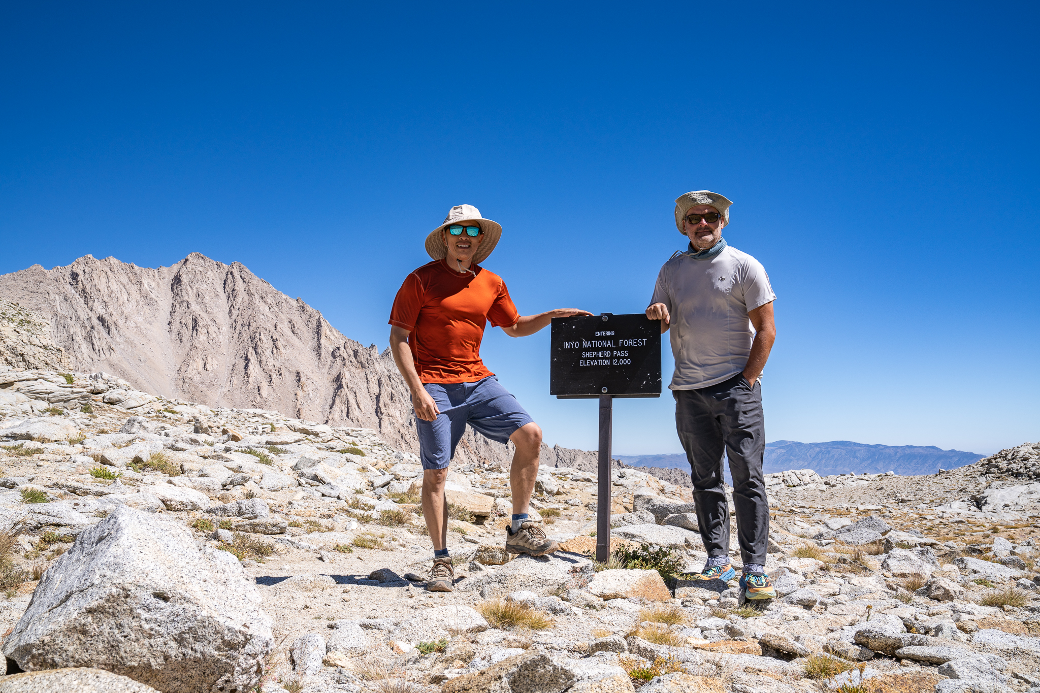
    “The sun is up,” Brad’s voice jolts me.

    I leap out of my sleeping bag, jump out of the tent, grab my wide-angle lens, and crank down the aperture. I race along the shores of Lake 11,400’, chasing the border where light meets shadow, trying to capture perfect sun stars. As I reach the southern shore, I snag a double star—one behind Mt. Tyndall, and the other mirrored in the lake below. The rising sun begins to burn off the morning dew, and wildflowers open up to embrace the warmth. I switch to my macro lens, capturing delicate details.

    Meanwhile, Brad is getting breakfast started. It’s the usual oatmeal, coffee, and scones, though later we’ll realize we forgot the honey. Since today is our easiest day, we linger over breakfast, soaking in the calm of the lake and the wide-open landscape before us.

    When we finally set out, we opt for a cross-country route heading east through the valley, which spares us the drop down onto the JMT. Being above the tree line, the route is straightforward. We make a direct line toward Mt. Tyndall. As we tiptoe across Tyndall Creek, I tell Brad that this really is a perfect place.

    We join the Shepherd Pass Trail directly across from Rockwell Pass and slowly wind our way up the gentle slopes. Compared to the grueling climb to Forester Pass, today’s hike feels almost leisurely. The elevation gain is mild, as we’re already on a high, treeless plateau, with a few small creeks braiding across the trail.

    But the wind is relentless. At the top of Shepherd Pass, it howls. I set up a low tripod to take our pictures, constantly worried that the wind might knock over the camera. The other side of the pass is a long scree slope, as dizzying as the south side of Forester Pass. With the wind whipping around us, I ask Brad to tuck away my hat so it doesn’t blow into my face during the scary descent.

    I brace against the fear of sliding down the steep incline, taking slow, deliberate steps. For a brief moment, I consider asking Brad to tell Yan, “I love you,” if something were to happen to me. Once we’re past the scariest part, I check my phone. There’s signal! I quickly send a few texts to Yan and even manage to call her. It’s so good to hear her voice.

    We descend rapidly, leisurely almost, leaving the scree field behind and passing The Pothole. The barren moonscape transitions into a pine forest, and we can hear Shepherd Creek’s soothing song. Before long, we arrive at Anvil Camp.

    It’s only 2:00 in the afternoon. We snack on leftover lunch and then scout for a better campsite. Across the right bank, nestled among foxtail pines and next to a small meadow, we find the perfect spot. Beyond the meadow, the dry slopes are dotted with boulders and more pines. I find a cozy place for a warm afternoon nap. In the meantime, Brad naps on the tent’s footprint.

    At 4:00, we start the afternoon routine. Set up camp, shampoo, and wash. Brad sees me shiver in the pool of snowmelt and decide against bathing. We make dinner. Tom Kha soup is ready in no time, and Brad shaves carrots for the Pad Thai. A squeeze of fresh lime gives the dish a bright, fresh kick.

    It’s our final night out. I get a flashback to our hike out on the last day in Rainier, when a light rain swept over us and brought on the feeling of accomplishment, of connectedness, of contentment, all wrapped into one. The blue and orange shirts I wore on that trip are still with me now. Fifteen years have passed since that trip, but the memories, though distant, feel vividly clear.

    After a camp-style apple pie, I drift off to sleep, lulled by the sound of Shepherd Creek rushing by, as scenes from backcountry trips of yesteryears play in my mind.


  • Forester Pass

    Forester Pass

    Kearsarge Pass | Center Basin | Forester Pass | Shepherd Pass | Shepherd Creek

    Part 3

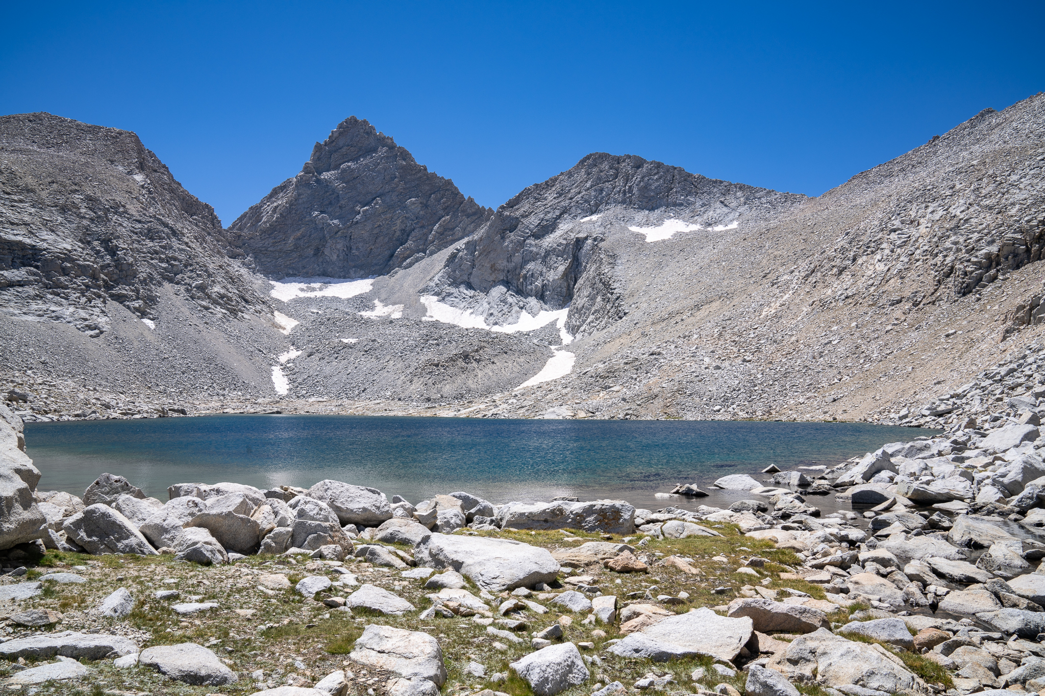
    Breakfast is the same, yet somehow it gets better each morning—hearty oatmeal mixed with honey, pour-over coffee, and scones that hit the spot.

    Sunbeams dance on the stream like shards of glass, casting shades of amber, emerald, and turquoise. The inlet at Golden Bear Lake flows stronger today, a subtle shift from yesterday’s calm. We know today’s going to be tough, so we pack up, soaking in the last views of this stunning basin.

    Back on the JMT, the trail wastes no time—its relentless ascent toward Forester Pass begins almost immediately. Along the way, we spot a family of Sierra grouse nestled in the brush. The path bends eastward, then curves south, quickly lifting us above the trees into a world of eroded granite and spartan pools.

    At 11,654 feet, we hop across an idyllic stream. A large flat boulder by the water is a clear favorite among hikers—a perfect spot to pause. Straight ahead, the notch of the pass comes into view, and the cascading waters seem to sing, their melody drowning out our labored breaths in the thin air. Brad turns to me and says, “If I die before you, I’d like you to scatter my ashes here. Bring my kids with you. Anyone who cares can hike in to visit.” He’s not trying to be morbid, he adds, just that these mountains are so magnificent, so spectacular, and from here, the view is unbeatable.

    We shift to happier thoughts as we tackle the switchbacks up to the final lake before the pass. It’s our last chance to snack and fill up on water. The last few hundred feet are grueling, each step demanding a deliberate breath. But soon enough, we make it.

    Forester Pass! At 13,200 feet, it is the highest point along the Pacific Crest Trail and lives up to its reputation as being one of the most difficult passes along the JMT.

    I peer down the southern side, and the view is dizzying. The trail clings to the granite face, a misstep away from a long fall. Carefully, I place one foot after another, hugging the cliffside as we descend. At the bottom of the steep section, we find a picturesque lake, the perfect spot to break for snacks and refill our water.

    The next section is a speedy hike down gentle slopes along the west side of Diamond Mesa. We make quick progress, dropping into the Tyndall Creek drainage basin. Knowing our camp is near the trail to Lake South America, we veer off-trail at 11,400 feet, following the contour lines, dodging boulders and downed pine trees. Before long, our destination—a nameless lake at the same altitude—comes into view.

    This lake, which I’ll call Lake 11,400’, is like an infinity pool. The opposite shore forms a low rim, hiding the meadow below. Beyond the rim, Polychrome Peak, Mount Tyndall, Tawny Point, and the surrounding skyline rise dramatically.

    We are exhausted, having covered about twelve miles and crossed the notorious pass. The rest of lunch has lost its appeal, so we ditch it and focus on dinner. Tonight’s menu: egg drop soup and beef-flavored ramen with vegetables. The brownies for dessert didn’t survive the trip intact, but they’re still delicious, even eaten with a spork.

    As the near-full moon rises behind the eastern peaks, I capture a few shots during the evening’s blue hour. It doesn’t take long before sleep pulls me under.